https://www.cpc.ncep.noaa.gov/products/ ... xus07.html
30-DAY OUTLOOK DISCUSSION FOR MARCH 2023
The March 2023 temperature and precipitation outlook is particularly
challenging this year as an active, robust MJO and a nearly certain SSW need to
be considered when making the forecast, both of which to occur within a
continued solid La Nina atmospheric base state. In addition to considering
these physical drivers, current anomalous snow depth and both dynamical and
statistical model forecast guidance is utilized in preparing the outlook.
The March temperature outlook favors below-normal monthly mean temperatures for
South Alaska including the Alaska Panhandle, much of the western CONUS eastward
to the northern Plains, western Great Lakes and New England. Areas forecast for
Alaska, much of the western U.S. and the northern Plains are supported by
background La Nina conditions that continue to remain in place in the
atmospheric circulation in the north Pacific Ocean and much of the North
America. Even though equatorial Pacific negative SST anomalies continue to
become less negative, the atmospheric response is likely to remain during much
of the month of March.
Also, the MJO enhanced convective phase is currently located in the western
Pacific as depicted by the RMM index and slightly further east with respect to
anomalous velocity potential. Lagged MJO composites anchored to the current RMM
phases 6-7 favor a pattern change to more consistent, phased troughing over the
West coast and far western CONUS prior to and during early March. Odds for
negative 500-hPa height anomalies and below-normal temperatures extended
eastward across the remainder of the northern half of the CONUS are also
elevated as a result of this evolution. Extended range and subseasonal range
dynamical model guidance is generally consistent with this outcome.
Monthly model guidance from the NMME initialized at the start of February or
earlier favor the canonical La Nina anomalous temperature pattern. If the MJO
remains active, the second half of the month of March may see a return to
constructively interfering ridging for the Southeast and areas just to the
north and west (forced by La Nina and the MJO). Consequently above-normal
monthly mean temperatures are favored in the outlook for the Southeast, Gulf
coast and southern Plains. Highest odds are forecast from eastern Texas to the
Florida Panhandle.
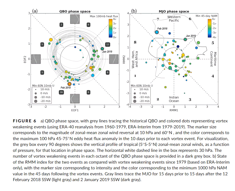
The eventual impact of the SSW for the U.S. is considerably uncertain. The fact
that short term forecasts are in very good agreement that a SSW will occur in
the next few days is enough to a slight degree further elevate chances for
below-normal temperatures on its own most likely later in the month. The SSW
and so weakening of the stratospheric polar vortex and more variable/meridional
jet stream makes the potential for arctic air outbreaks in the northern
hemisphere more likely in March. However,
there is high uncertainty with SSW
events whether impacts will significantly affect the troposphere (i.e. AO
index) to a sufficient degree to impact the eventual observed anomalous
temperature. Currently the GFS and ECMWF guidance does not have the warming
impacting the surface through the start of March, but this could happen later
in March. Moreover, even if so, it is not a certainty that any arctic air
outbreaks primary center of action will be in the western hemisphere, rather it
is possible to more strongly impact Asia or Europe.
FORECASTER: Jon Gottschalck


 free image hosting