Puur SSW, nog steeds MJO neutraal. Gaat veranderen dus
Stratosfeer winter 2020/2021
Re: Stratosfeer winter 2020/2021
Er is overigens wel genoeg downwelling, die helpt het Groenlandhoog in het zadel. Alleen de westelijke NAO- werkt tegen.
Puur SSW, nog steeds MJO neutraal. Gaat veranderen dus .
.
Puur SSW, nog steeds MJO neutraal. Gaat veranderen dus
Je hebt niet voldoende permissies om de bijlagen van dit bericht te bekijken.
-
Sebastiaan
- Berichten: 12294
- Lid geworden op: 31-12-1977
Re: Stratosfeer winter 2020/2021
Op de LT zie ik wel de downwelling verminderen.
Je hebt niet voldoende permissies om de bijlagen van dit bericht te bekijken.
Re: Stratosfeer winter 2020/2021
Hier is nog altijd een licht tot matig vertrouwen in een eventuele vertaling naar betere weerkaarten voor ons deel van Europa. Dat denk ik af te leiden uit de laatste bijdragen in dit topic.
Ik heb bij de overzichten GWL intussen diverse situaties met een zuidelijke westcirculatie gevonden, waarbij de maxima in Nederland tussen + 6 graden en +11 graden bleven optreden.
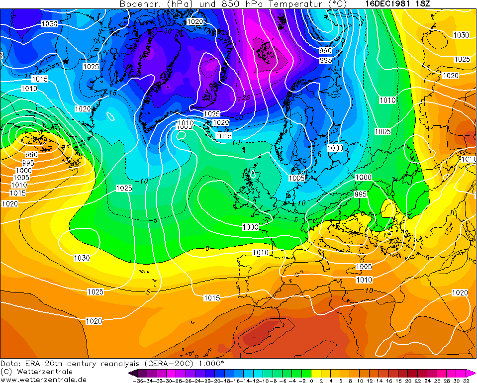
In mijn jongere jaren ben ik nog opgevoed met het idee dat de zuidelijke westcirculatie actie betekende in koude lucht. December 1981 was een voorbeeld.
Ik heb bij de overzichten GWL intussen diverse situaties met een zuidelijke westcirculatie gevonden, waarbij de maxima in Nederland tussen + 6 graden en +11 graden bleven optreden.
In mijn jongere jaren ben ik nog opgevoed met het idee dat de zuidelijke westcirculatie actie betekende in koude lucht. December 1981 was een voorbeeld.
Re: Stratosfeer winter 2020/2021
Dat was toen toch helemaal andersJohn schreef: ↑18-01-2021 16:49Hier is nog altijd een licht tot matig vertrouwen in een eventuele vertaling naar betere weerkaarten voor ons deel van Europa. Dat denk ik af te leiden uit de laatste bijdragen in dit topic.
Ik heb bij de overzichten GWL intussen diverse situaties met een zuidelijke westcirculatie gevonden, waarbij de maxima in Nederland tussen + 6 graden en +11 graden bleven optreden.
In mijn jongere jaren ben ik nog opgevoed met het idee dat de zuidelijke westcirculatie actie betekende in koude lucht. December 1981 was een voorbeeld.
Re: Stratosfeer winter 2020/2021
December 1981 werd ook gekleurd door een SSW. In deze tijden hebben we helaas voortdurend tegenwerking van de AGW. Die pakt vooral slecht uit in de wintermaanden (en vroege lente).John schreef: ↑18-01-2021 16:49Hier is nog altijd een licht tot matig vertrouwen in een eventuele vertaling naar betere weerkaarten voor ons deel van Europa. Dat denk ik af te leiden uit de laatste bijdragen in dit topic.
Ik heb bij de overzichten GWL intussen diverse situaties met een zuidelijke westcirculatie gevonden, waarbij de maxima in Nederland tussen + 6 graden en +11 graden bleven optreden.
In mijn jongere jaren ben ik nog opgevoed met het idee dat de zuidelijke westcirculatie actie betekende in koude lucht. December 1981 was een voorbeeld.
Ik zie nog wel ruimte voor situaties met (natte) sneeuw in het weekend en kort daarna. Volgende week weer zachter, maar met SSW-invloed is nog matiging denkbaar.
Later in de maand zien we een nieuwe opwarming optreden in de stratosfeer. Die gaan meestal gepaard met positieve AO, daarna weer dalend. Februari is nog open voor wat betreft winterweer. De SPV blijft voortdurend zwak, heel anders dan in 2019 toen hij juist extra aan kracht won in februari.
O, ik zou wat geven voor een wintermaand als die van veertig jaar geleden.
Je hebt niet voldoende permissies om de bijlagen van dit bericht te bekijken.
-
Sebastiaan
- Berichten: 12294
- Lid geworden op: 31-12-1977
Re: Stratosfeer winter 2020/2021
Uitstekende EC46-update. Zoals eerder genoemd. Negatieve NAO-> Blokkade
Je hebt niet voldoende permissies om de bijlagen van dit bericht te bekijken.
-
Sebastiaan
- Berichten: 12294
- Lid geworden op: 31-12-1977
Re: Stratosfeer winter 2020/2021
Ik zie een behoorlijke dip 
Je hebt niet voldoende permissies om de bijlagen van dit bericht te bekijken.
-
Sebastiaan
- Berichten: 12294
- Lid geworden op: 31-12-1977
Re: Stratosfeer winter 2020/2021
The #SSW show is on  WaF still makes trouble for a weak PV! Now the EC ens mean shows a split under development, with modest WaF, and so does many ensembles in EC12 ens mean. A 2-cell lower and upper PV structure => ridge over NC-Greenland => The "Beast" setup is spotted https://twitter.com/TradeWpower?ref_src ... 2%3Fs%3D19
&
About 12 shows full split favourable for The Beast, some shows split favourably for solid winter for the Nordics only but most shows that a split is under development... This is far out but a signeficant signal
https://twitter.com/TradeWpower/status/ ... 7522486272
&
About 12 shows full split favourable for The Beast, some shows split favourably for solid winter for the Nordics only but most shows that a split is under development... This is far out but a signeficant signal
https://twitter.com/TradeWpower/status/ ... 7522486272
Je hebt niet voldoende permissies om de bijlagen van dit bericht te bekijken.
-
Sebastiaan
- Berichten: 12294
- Lid geworden op: 31-12-1977
Re: Stratosfeer winter 2020/2021
Dit ziet er redelijk/goed uit.
Je hebt niet voldoende permissies om de bijlagen van dit bericht te bekijken.
Re: Stratosfeer winter 2020/2021
De MJO input ontbrak tot nu toe, veel anders dan in 2018. De SSW alleen bleek te weinig afgelopen weken, ondanks de goede downwelling.
Wat ook speelt bij de haperende winterkansen is de nieuwe SSW die in gang lijkt te zijn gezet. In mijn beperkte ervaring met de SSW was dit mij onbekend, maar zelfs een oude rot als Judah Cohen wordt erdoor verrast, zo niet overvallen. Deze quote verdient extra aandacht:
There is a Yiddish saying that probably many of you are familiar with - “Mann Tracht, Un Gott Lacht” which means “Man Plans, and God Laughs.” This is not the blog that I had planned but the cold, hard reality is leaving me no choice. I did think that I had troposphere-stratosphere-troposphere/PV weather coupling all figured out (this is of course an exaggeration – I think I know the broad strokes but the devil is in the details and there is a lot that I don’t know) and now Mother Nature serves up an event that I am unfamiliar with and struggling to understand and anticipate the implications for our weather. As I have discussed on Twitter, it is very puzzling to me to have strong/active vertical Wave Activity Flux (WAFz and is proportional to poleward heat transport) after a significant weakening of the PV (see Figure 12), especially one that crosses the threshold for a major mid-winter warming (MMW where the zonal winds reverse from westerly to easterly at 60°N and 10 hPa). As I showed in Figure 4 from Cohen and Jones (2011) and shown earlier by Polvani and Waugh (2004) as I show in Figure i, positive WAFz comes to an abrupt end at the Central Date (when the winds reverse from westerly to easterly in the stratosphere and in fact is negative for an extended period. According to Polvani and Waugh the negative WAFz can last up to two months. But as seen in Figure 12, the WAFz continues to remain active following the initial wind reversal in the polar stratosphere the first week of January and will remain active right through the end of the month. I do have the winter season daily WAFz for every winter going back to 1969 and I cannot find another example of active WAFz following an MMW. To just show how unprecedented this may be, there is the possibility of have two separate MMWs this winter separated by about a week based on the most recent EPS weeklies. There have been two MMWs in one winter before but usually they are separated by months and not a week or two. As far as I know this has never happened before.
https://www.aer.com/science-research/cl ... cillation/
De effecten van de twee SSW's interfereren met elkaar.
When WAFz is active (second column “active energy transfer”) it is relatively cold in East Asia and western North America but relatively mild in the Eastern US and Europe. Two to four weeks post the PV disruption it is likely to be relatively cold in the Eastern US and Europe while the cold in East Asia and western North America eases and both cannot be simultaneously true. Does the active WAFz cancel the impacts to the weather from the PV disruption, is the opposite true or both impacts are operating simultaneously.
Plaatje met de heatflux de afgelopen maand en de progs in de nabije toekomst:
Een split behoort opnieuw tot de mogelijkheden. Daarna echt doorwerking van de verstoorde stratosfeer?
Je hebt niet voldoende permissies om de bijlagen van dit bericht te bekijken.
Laatst gewijzigd door Paul op 19-01-2021 09:47, 1 keer totaal gewijzigd.