Stratosfeer en de invloed op ons weer
Re: Stratosfeer en de invloed op ons weer
Dank je Adrie voor je heldere uiteenzetting. Het is eenvoudige natuurkunde, maar niet minder nuttig bij het begrijpen van de stratosferische ontwikkelingen. Prettig om het aangehaalde principe vanuit jouw vakgebied bevestigd te zien worden.
-
Oud-forumlid
- Berichten: 79
Re: Stratosfeer en de invloed op ons weer
Mooi (zelfgemaakt door Recretos van netweatherfurom) filmpje van de stratosfeer van het 1 tot 150 hPa vlak!!
<iframe width="640" height="390" src="//www.youtube.com/embed/kgewmaKeo-I" frameborder="0" allowfullscreen></iframe>
<iframe width="640" height="390" src="//www.youtube.com/embed/kgewmaKeo-I" frameborder="0" allowfullscreen></iframe>
Laatst gewijzigd door Oud-forumlid op 14-01-2015 13:12, 1 keer totaal gewijzigd.
Re: Stratosfeer en de invloed op ons weer
Sebastian schreef:
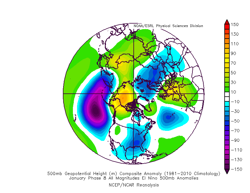
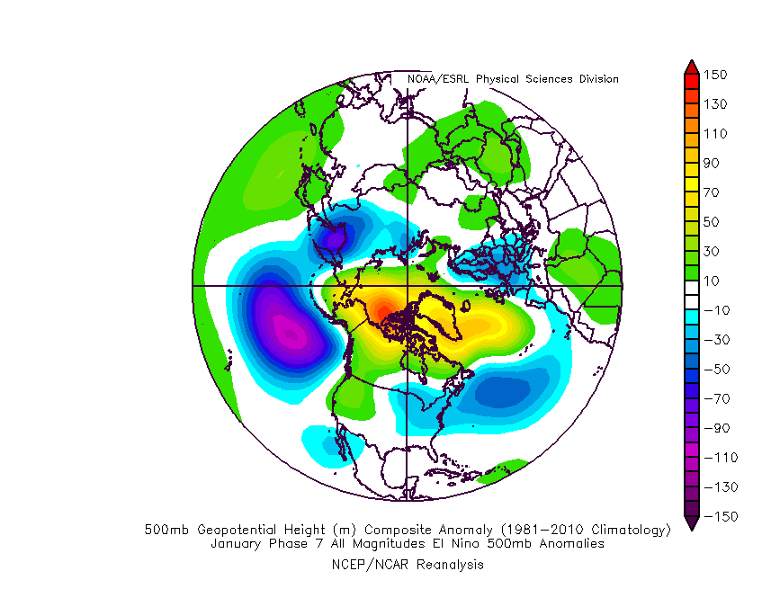
De verschillende modellen lijken fase 8 niet echt te bereiken, een gemiste kans.
Fase 8 lijkt voor de maand januari meer voor de USA kou te geven. http://www.americanwx.com/raleighwx/MJO/MJO/JanENMJOphase8all500mb.gifWij moeten het toch van fase 7 hebben.
http://www.americanwx.com/raleighwx/MJO/MJO/JanENMJOphase7all500mb.gif
Een afvlakkende MJO geeft nog maar weinig extra convectiesignaal.
Hopelijk is de MJO net als de westcirculatie (gaan we naar 4-waves ?) nu een tijdje tot rust gekomen
-
Sebastiaan
- Berichten: 12287
- Lid geworden op: 31-12-1977
Re: Stratosfeer en de invloed op ons weer
Bedankt voor de correctie.
Ondertussen geeft BBC-weerman Ian Fergusson aan, dat UKMO de MJO verantwoordelijk acht voor synoptische veranderingen. Fascinerend. Vraag me af waarom ze de stratosfeer niet noemen? In ieder geval niet in dit bericht.
UKMO regard EC DET as progressive outlier. Strong signal for colder or much colder weather next week, albeit extremely low skill on snow risk in any one area (not even worth speculating!). MJO phase root cause for the synoptic 'flip', they say. Some solutions look ominous, but a while before ANY worthwhile deterministic detail emerges for day-to-day prospects after the cold, cyclonic weekend has passed...
https://forum.netweather.tv/topic/82208-model-output-discussion-stormy-period-inbound/page-83#entry3117621
Laatst gewijzigd door Sebastiaan op 14-01-2015 14:09, 1 keer totaal gewijzigd.
Re: Stratosfeer en de invloed op ons weer
Inderdaad de verschillende fasen van de MJO beinvloeden de troposfeer en de stratosfeer verschillend en op verschillende tijdschalen.
Overzicht voor de stratosfeer is hier te vinden:http://onlinelibrary.wiley.com/doi/10.1029/2012GL053144/pdf
http://onlinelibrary.wiley.com/store/10.1029/2012GL053144/asset/supinfo/grl29549-sup-0002-fs01.eps?v=1&s=168afbc06f3d98e510adbbed2bf67ef7f3eb9eab
http://onlinelibrary.wiley.com/store/10.1029/2012GL053144/asset/supinfo/grl29549-sup-0001-readme.txt?v=1&s=50d3427af46d42261a3587ebc0022919b8c76dac
Voor de invloed op de troposfeer van de verschillende MJO fasen zie deze figuur uit recente pre-publikatie van Goss, M., and S. Feldstein, 2015: The impact of the initial flow on the extratropical response to Madden Julian
Oscillation convective heating. Mon.Wea. Rev. doi:10.1175/MWR-D-14-00141.1, in press
Laatst gewijzigd door Karel op 14-01-2015 17:06, 1 keer totaal gewijzigd.
Re: Stratosfeer en de invloed op ons weer
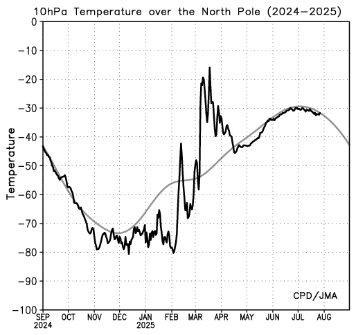
Vanochtend even naar de toestand van de stratosfeer gekeken. De temperatuur in het poolgebied loopt weer op. bron: http://ds.data.jma.go.jp/tcc/tcc/products/clisys/STRAT/gif/pole10_nh.gif

Re: Stratosfeer en de invloed op ons weer
Van het artikel van Goss en Feldstein kan ik alleen maar een abstract zien, dus ik kan er nauwelijks iets van vinden. Het is een modelstudie, aangevuld met waarnemingen, uit de waarnemingen komt veel minder signaal dan uit de modelstudie, maar er is toch nog skill voor de VS. In het plaatje wat ik hier boven zie, zou sterke MJO vooral op het PNA patroon invloed op een termijn van 10-20 dagen hebben. Alleen fase 7 zou op de oostelijke Atlantische Oceaan enig significant signaal kunnen hebben. Een anomalie van 50 m op 300 hPa is nog steeds heel weinig, de natuurlijke variatie van het 300 hPa vlak ligt eerder in de orde van 200-500 m. Overigens zijn die Mercatorprojecties verwarrend en hinderlijk in de poolgebieden, ze zouden beter een polaire projectie kunnen gebruiken.
Wat we gewoon natuurlijk eens kunnen doen is, een telling van de GWL naar Hess/Brezowsky (algmene referentie is Baur) voor verschillende tijdvertragingen (zeg van 0 tot 30 dagen) doen voor de verschillende fasen van de MJO met een amplitude van meer dan 1. De MJO dataset staat vast wel ergens, de eerste heb ik zo beschikbaar. Daarna kun je eens kijken naar temperatuur-anomaliën per seizoen. Ik vrees dat je op de laatste weinig of niets vindt.
Wat we gewoon natuurlijk eens kunnen doen is, een telling van de GWL naar Hess/Brezowsky (algmene referentie is Baur) voor verschillende tijdvertragingen (zeg van 0 tot 30 dagen) doen voor de verschillende fasen van de MJO met een amplitude van meer dan 1. De MJO dataset staat vast wel ergens, de eerste heb ik zo beschikbaar. Daarna kun je eens kijken naar temperatuur-anomaliën per seizoen. Ik vrees dat je op de laatste weinig of niets vindt.
Laatst gewijzigd door Adrie op 16-01-2015 14:08, 1 keer totaal gewijzigd.
-
Sebastiaan
- Berichten: 12287
- Lid geworden op: 31-12-1977
Re: Stratosfeer en de invloed op ons weer
Twin MT events are occurring. A strong Asian +MT (GWO Phase 4/5) and then a strong US -MT (GWO Phase 8/1) as fast acceleration of frictional torques are compensated by consecutive MT events which will send AAM tendency sharply downwards.
These twin torques are important for two reasons.
First because acceleration phases of global torque events (without going into the atmospheric complexities) signify weakening of sub tropical ridging and mean that the interference of the Azores High in the trough disruption process will be reduced more and more as time goes on.
Look how the ECM operational this morning picks up on this with the jet heading southward and the Azores High starting to decline towards days 8 to 10
This is not a discontinuous FI signal - it is underpinned as a logical evolutionary way ahead.
Taken at face value, the chart suggests that eastward push of energy displacing the cold eastwards and trough disruption ending and returning back to the same westerly phasing of the first half of the winter. So on the one hand one could suppose quite reasonably that the decline of the Azores High just leaves room for a fast jet to barrel through and the westerlies are back to stay - but it is nowhere near as simple as that.
The southward moving jet is an early stage signal of the AO starting to tank negative. Polar ridging likely to return with -EPO ridge. Sounds familiar here but worth reading on
Phase 1/2 GWO looks protracted as suspected and signals a continuation of weak polar jet flow - no surprise to see the models put back the flatter pattern and westerly return beyond the t120 to t144 time period. Ian F's confirmation that UKMO operational is once again too progressive end of week underpins this notion very well.
With the timetable put back once more to the post day 6/7 period - we now turn to the second reason those twin torques are very important.
The stratospheric vortex remains ( seemingly as ever!) a punch away from knock out. We have drawn the short straw this winter so far with a junior SSW split vortex that, thanks a bunch, created a Canadian/Greenland vortex little brat family which has gone about wreaking havoc with seasonal prospects and delivered further extended chilly autumn conditions instead. At least away from more northern parts who have benefitted better from colder zonality conditions :)
That is up to now of course. completely realise we have been here before too many times, but I think that current stratospheric model indications are building towards something more favourably placed than last time.
A pincer type process is developing across the polar field. Already mentioned return of the -EPO poleward ridge. Cold air also this time is becoming entrenched close to us and especially to our north and east with, on the other side of the arctic, the Siberian High extending a strong ridge westwards and creating an increasingly disruptive wall to Atlantic troughing.
With the GWO set on a protracted Phase 1/2 and meaning that amplified polar flow is encouraged in the Atlantic (along with the signal to weaken the Azores High) we *could* be looking at the first signals that the NAO is finally going to head negative more and more towards months end and more especially into the new month.
I say this especially, because although more modelling is obviously required both tropospherically and stratospherically, indications of a possible displacement vortex event give us a much improved chance of benefitting this time around with a better Atlantic profile and much more pressure to eject the upper vortex to our North west. With GWO induced strong twin MT wave activity likely to manifest on the vortex over the coming 10 to 15 days there is enough vertical wave activity programmed there to assist a tanking -AO profile, under the weakening polar westerly profile.
Transitions like this can be messy and liable to temporary setbacks - but there is plenty of ammunition in the pipeline to ensure that any transitional phase when the jet comes south and vortex energy is ejected out is blunted by dropping out of zonal westerlies as negative zonal wind build up is burst out to the surface. Most important in this regard, is that sufficient vorticity energy is displaced away from the Atlantic sector for the first time this winter
This means that we *could* see a protracted and messy trough disruption process finally lead to a cut off low and a better amplified ridge extension over the top then extending eastwards across the NE Atlantic towards Iceland and Scandinavia. This is an attractor state to pull the Siberian High westwards and sets up the enticing prospect of something akin to a Feb 91 scenario coming into focus by end of the month but perhaps more especially so into February. *Shameless ramp disclaimer*
A bold prediction (obviously) maybe and lots of modelling to get through first..... but lets just see.
Edit: FWIW, I think that the MJO signal, with shortening wavelengths heading into the final third of winter is likely to increasingly have different implications as tropical versus mid-latitude feedbacks change
Nieuwe update van Tamara. https://forum.netweather.tv/topic/82300-model-output-discussion-16th-jan-12z-onwards-smile-while-you-post/?p=3127546
Bij GFS zit al een aantal runs achter elkaar, een flinke opwarming. Gaat er na een minor SSW een major SSW komen? NIeuwste MJO update laat EC richting fase 6 gaan (wel erg ver weg!)
Laatst gewijzigd door Sebastiaan op 18-01-2015 20:20, 1 keer totaal gewijzigd.
Re: Stratosfeer en de invloed op ons weer
Ik lees een groot verhaal (van wie?) waar van alles aan van alles gekoppeld wordt en allerlei vermeende causaliteiten worden benoemd. Vermeend, omdat er een paar keer *could* staat. Alleen is het, waar het betrekking heeft op West-Europa, totaal niet reproduceerbaar in de div. Uitvoer. Als ik naar de div. GFS ens en EC Eps Uitvoer kijk, zeg de 1900/1912 Uitvoer, zie ik juist een sterke zonalisering naar het eind van de maand...Wat ik vaak jammer vind van dit soort uitgebreide beschouwingen, is de schrijver er meestal nooit op terug komt. Dus een soort van evaluatie achteraf. Het is toch een prognose en een stuk reflectie daarop lijkt me nuttig. Anders blijft het voor mij allemaal nogal speculatief.
-
Oud-forumlid
- Berichten: 1819
Re: Stratosfeer en de invloed op ons weer
En dan week in, week uit die speculaties moeten aanzien terwijl je gewoon ZIET hoe de constellatie op de kaarten ligt en het dadelijk weer maart is na alwéér een totale westwinter.
Op WeerWoord zijn dit en de vorige winter de belachelijkste aller tijden. Het eeuwige 'quizás mañana', altijd 'een lichtpuntje' op +240h ofzo, dag in dag uit..
Heren, dames, die SSW's zijn een normaal verschijnsel in onze winter. Zachte winters zijn ook normaal (er is geen verband). Het verder verzachten van onze winters is óók normaal (er is geen verband met vorige twee items: AGW is onafhankelijk).
Mss dat na heel veel onderzoek en modelleren het stratospherische gedrag onze voorspellingshorizon met een dag of twee, drie verlengen kan. Ben ik nog optimistisch ook.